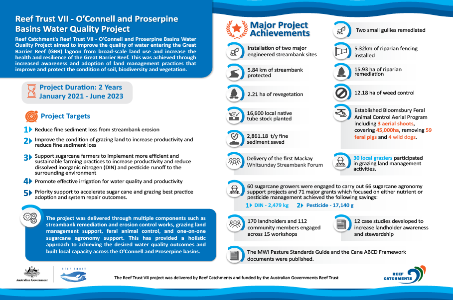

Reef Trust VII is an Australian Government Reef Trust funded program which aims to improve the quality of water entering the Great Barrier Reef (GBR) lagoon from broad-scale land use to increase the health and resilience of the Great Barrier Reef. This will be achieved through increased awareness and adoption of land management practices that improve and protect the condition of soil, biodiversity and vegetation. The project goals include:
- Reduce fine sediment loss from streambank erosion
- Improve the condition of grazing land to increase productivity and reduce fine sediment loss
- Support sugarcane farmers to implement more efficient and sustainable farming practices to increase productivity and reduce dissolved inorganic nitrogen (DIN) and pesticide runoff to the surrounding environment
- Promote effective irrigation for water quality and productivity, and
- Priority support to accelerate sugar cane and grazing best practice adoption and system repair outcomes.
The project runs for a period of three years (2021 – 2023) and will engage numerous local service providers from across the Mackay and Whitsunday region. Landholders participating in the project will be undertaking a wide variety of works, including but not limited to stock management, pasture improvement, land type fencing and watering points, sugar cane farming nutrient and pesticide application plans, sugar cane farming irrigation efficiency improvements, streambank engineered works, riparian revegetation and weed control.
There are multiple components to the project which provides a holistic approach to achieving the desired water quality outcomes and building capacity across the O’Connell and Proserpine basins. Each component of the project is described in more detail below.
Streambank Restoration
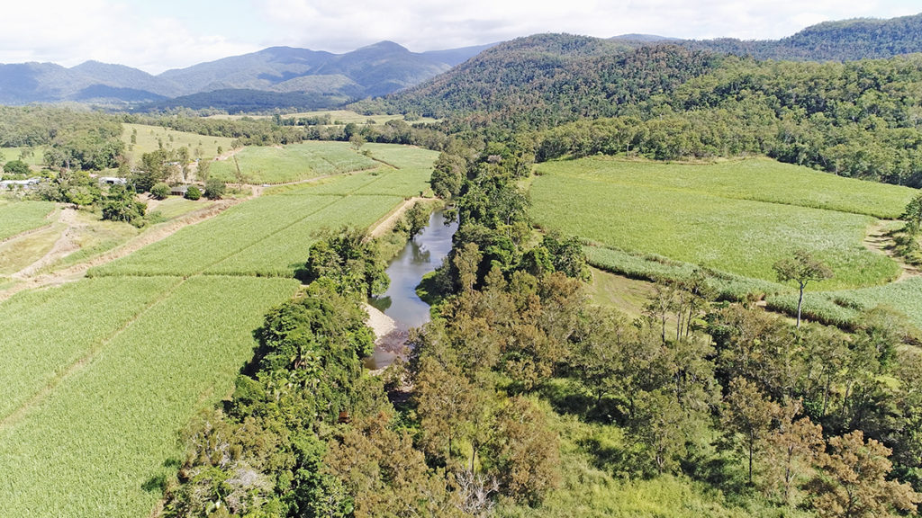
Streambank erosion is a significant contributor of fine sediment delivery to the Great Barrier Reef (GBR) lagoon. Previous streambank stability assessments have identified the O’Connell Basin as a priority area for reducing fine sediment loss. The basin includes the O’Connell River, Andromache River, Murray Creek, St Helens Creek and Reliance Creek catchments. As well as sediment loss, streambank erosion contributes to the loss of productive agricultural land across the basin.
Reef Catchments has partnered with environmental engineers specialising in geomorphology and riverine stability assessments to identify high priority erosion sites. Site selection includes utilising existing LiDAR Imagery, stream type assessments, local landholder knowledge and specialist inputs.
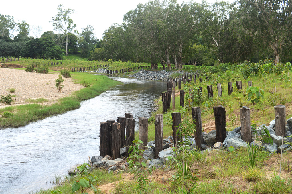
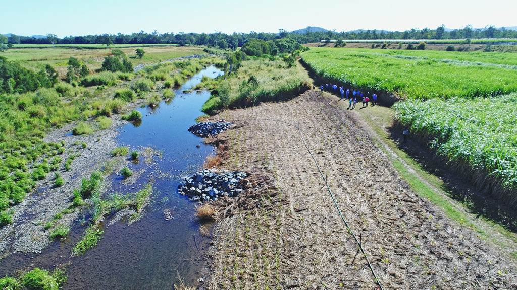
Erosion Control
Reef Catchments will implement current best practice methods of engineered erosion control that have been used successfully throughout the Mackay Whitsunday region. Examples of erosion control methods include rock revetment, rock groynes, timber pile fields, pin groynes and rock chutes. The desired outcome of erosion control works is bank stabilisation as well as restoring or reproducing the natural state of the watercourse to slow the velocity and reduce the erosive energy of the water. The most suitable control method is determined by the site’s engineer through a project design phase.
Engineered works to control erosion are often a last resort and are used where extensive erosion has occurred and has or will cause considerable damage to productive farmland and/or infrastructure. These methods are often quite expensive and labour intensive, however, when coupled with riparian revegetation can be effective in reducing fine sediment loss and protecting the bank while also promoting riparian connectivity and the establishment of instream habitat.
Controlling stock access to the waterways is a proven, cost-effective method of reducing erosion. Stock walking up and down banks to water in creeks creates a stock pad that they use all the time. This creates a channel with no grass cover towards which overland flow will naturally gravitate. The water picks up the soil and transfers it to the watercourse. Over years of use, these will get deeper and deeper and become what is known as a nick point. These often end up developing into head cuts (starting point for an erosion gully) that can travel into the paddock and get longer, wider, and deeper. They are difficult to control once they have started. The Reef Trust VII project addresses erosion from stock access to waterways in the Grazing component.
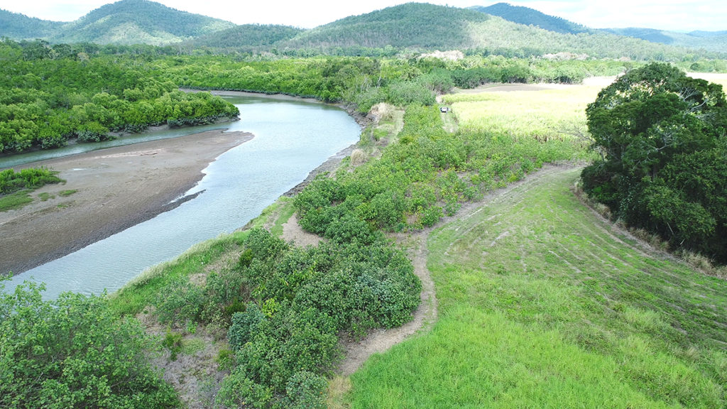
Revegetation of riparian areas
Riparian zones with structurally diverse native vegetation offer a wide range of ecological functions and services which should be protected and maintained to ensure the health and resilience of local waterways. Riparian vegetation is essential to prevent streambank erosion and provides additional benefits such as buffering sediment and nutrient run-off, improving water quality, providing habitat for terrestrial and aquatic species, and regulating stream temperatures and light.
Remediation and maintenance of riparian areas will be carried out as part of streambank erosion control measures to further assist with streambank stabilisation, reduce fine sediment loads, improve riparian connectivity and increase biodiversity.
Grazing
The grazing component of the Reef Trust VII project assists graziers in the adoption of practice improvements that reduce fine sediment loss from grazing land within the O’Connell basin. The project focuses on reducing erosion, improving the condition of soil and vegetation connectivity, and reducing the loss of fine sediments from grazing land to the Reef. Reef Catchments will work one on one with graziers to identify areas of concern and or impact and assist in the design and implementation of management plans to achieve water quality and pasture improvement outcomes.
The outcomes of the grazing component of the project include:
- Long term, enduring reduction of fine sediment loads through reduced erosion in the O’Connell Basin
- Improve riparian resilience through streambank stabilisation and improved structural diversity of vegetation
- Improved grazing pastures and legacy of a grazing manual support tool
- Improve the condition of soil and vegetation connectivity to reduce the loss of fine sediments from grazing land in the O’Connell Basin
- Increased landholder awareness and stewardship regarding land management practices
Riparian fencing and off stream watering points are a significant aspect of the grazing component, however the importance of pasture improvement, not only to increase herd carrying capacity but to also improve soil condition, structure, and ground cover to reduce sediment losses are also areas of high focus. Incentives to encourage these changes, supported by agronomy advice to adopt industry best practice, are available to landholders.
Cane
The cane agronomy component of the Reef Trust VII project provides sugarcane growers within the O’Connell and Proserpine basins incentives to reduce losses DIN and pesticides through precision agriculture and effective irrigation practices. Local agronomic service partners will work one on one with landholders to identify strategies which will minimise losses and promote farm profitability through development of farm nutrient and pesticide plans.
Knowledge gaps and cost associated with technological advancement have been identified as significant factors in the delayed uptake of Best Management Practice (BMP) adoption within the cane industry. The project will assist growers to investigate and instigate changes that lead to improved productivity and profitability, coupled with reduced DIN, fine sediment, and pesticide load losses into the O’Connell and Proserpine catchment areas. Incentives are available to growers receiving agronomy support through the project to co-fund purchase of and upgrades to equipment that will accelerate water quality improvement practice adoption.
System Repair
The system repair component of the Reef Trust VII project aims to identify high priority revegetation and maintenance locations for management intervention to ensure long term stabilisation and improved corridor connectivity and biodiversity. This project will target priority areas which are likely to provide both up and downstream benefits for reach stability throughout the O’Connell Basin. The broad system repair investment areas include:
- Weed Control
- Feral Animal Control, and
- Revegetating Habitat.
Weed Control
Weed infestations can cause significant issues throughout a streambank and riparian system. Weeds tend to outcompete native species and choke out natural recruitment and structural diversity within riparian zones. Weed control throughout this program aims to improve natural regeneration of riparian vegetation along the waterways within the O’Connell Basin.
Elephant grass and other similar grass weed species pose an issue throughout the O’Connell basin because they have a shallow root system and quite often hide serious erosion problems. Often during a flood, you will see large islands of grass floating down a river. This is usually elephant or similar types of grasses that have collapsed from the bank. This leaves a large, exposed area of bank that is vulnerable to further erosion Controlling these weeds gives the native seed banks a chance to germinate and grow.
Feral Animal Control
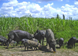
Feral animals cause significant issues throughout a catchment including but not limited to economic burdens, habitat destruction, disease transmission and native species declines. The system repair component of the project includes a small portion of funds for feral animal control, which will be utilised to partner with Whitsunday and Mackay Regional Councils to orchestrate at least three feral pig aerial control activities throughout the O’Connell Basin.
This partnership is aiming to promote the development of a local syndicate within the O’Connell catchment which will be an expansion of the existing and proven Whitsunday Feral Animal Shooting Program coordinated by Whitsunday Regional Council. Supporting the local landholders to participate in the Whitsunday Aerial Shoot Program will promote a catchment scale approach to feral pig management, which could see benefits across all the region’s basins.
Revegetating habitat
The habitat revegetation component of the project aims to strategically work with landholders throughout the O’Connell Basin to deliver biodiversity, connectivity and riparian resilience outcomes. The project will ultimately strengthening the riparian habitat corridor and enhancing in-stream habitat and overall reach connectivity, while also reducing the amount of sediment entering the Great Barrier Reef lagoon.
Typically, riverbanks and riparian areas harbour a majority of native vegetation remnants and local biodiversity values, while also being wildlife corridors and habitat refuges. Therefore, riparian areas identified as lacking native vegetation coverage are considered a high priority for the revegetating habitat component of the project. Site selection will be determined by whether an area can join to existing native riparian vegetation, creating a corridor, which will assist in improving riparian connectivity and reach scale stability.
Once sites are identified, Reef Catchments will work with landholders to improve structure and connectivity through revegetation activities. Planting a variety of local native species to improve structural diversity of vegetation includes deep rooted trees to hold banks, shrubs to bind soils, and ground covers with matted root systems to protect surface and subsoils.
For further information about the Reef Trust VII project and expression of interest process please refer to the project information guide or contact the Reef Catchments office.
Resources
LIDAR – Enhancing Local Capacity
SSP – Tariff Review Highlights Opportunities to Save
SSP – Impeller Trim – a Low Cost Solution to Performance Improvement
SSP – Irrigweb: An Irrigation Scheduling Tool
Farmacist – Improving the Accuracy and Efficiency of Chemical Applications
Farmacist – Improving the Accuracy and Efficiency of Fertiliser Applications
Farmacist – Improving Farm Management Decisions Through Planning
Farmacist – Improving the Accuracy and Efficiency of Chemical Applications
MAPS – Advantages to Planting a Legume Crop
MAPS – Zero Till Planting of Legumes
MAPS – Changing Fertiliser Application
MAPS – Increase Profitability While Reducing Pesticide Application