
Work by Reef Catchments on land adjoining the O’Connell River aims to make a significant difference to water leaving the property which will reduce pollutant and runoff levels both in the waterway and to the reef.
Reef Catchments healthy waterways project officer, Chris Dench, said the O’Connell River, south of Proserpine, had been identified as a significant contributor of sediment to the Great Barrier Reef with a large proportion derived from channel erosion.
“In an effort to reduce sediment and nutrient exports, and to improve the aquatic health of the river, Reef Catchments commissioned a stability assessment to understand the location, cause and extent of channel erosion through the O’Connell River,” he said.
“This river provides areas of important aquatic and terrestrial habitat for native species and is an important water source for irrigating productive grazing and sugarcane land.”
Reef Catchments has been undertaking works to improve water quality and aquatic and terrestrial health within the region through a range of activities including bank stabilisation on some of the region’s major rivers.
With funding provided through the Australian Government Reef Programme, a LiDar capture of the river was taken to be able to develop Digital Elevation Models of difference by overlaying LiDar from 2013 with Lidar from 2009.
The digital elevation model of difference was used to assess sediment loss over the four year period. Combined with an analysis of stream power and the use of hydraulic modelling, Reef Catchments identified and prioritised on-ground actions to reduce the supply of sediment and nutrients.
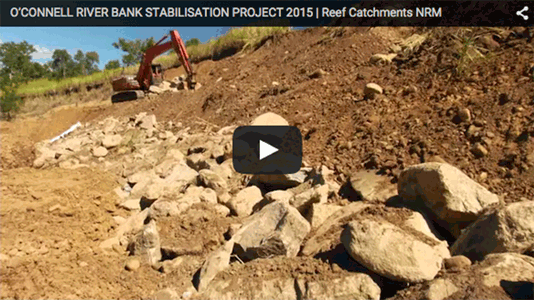
Mr Dench said Reef Catchments had been working with landholders and undertaking works along the O’Connell River to prevent future channel change.
“One particular site lost 9,000m3 of river bank between 2009 – 2013 and is expected to lose considerably more over the coming years ahead. Because of this loss, it has been listed as a high priority site.
“A range of potential options were identified to stabilise the eroding bank which ranged from low cost with a high risk of failure, to high cost with a low risk of failure.
“We worked with the landholder to identify potential resources, and the selected option was a 2m rock toe which ranked as having a high likelihood of success.”
The design included the rock toe placement followed by revegetation of the bank with native species. Woody debris was also placed in the river bed to create refuge for aquatic species.
This project is a Reef Catchments initiative, through funding from the Australian Government Reef Programme.
With thanks to:
- Landholder Tom O’Donnell
- Alluvium Consulting Australia
- GM Grader Hire
- Whitsunday Catchment Landcare