
Written by: Chanelle Barrett, Drought Resilience Coordinator
You’ve probably seen plenty of headlines this year about a record-breaking El Niño. The Bureau of Meteorology confirms a strong event is underway and is expected to peak in early summer. While El Niño is likely to strengthen further, its impact on rainfall isn’t always straightforward, particularly for our part of Queensland.
Weather drivers
El Niño is just one driver of our weather. Ocean temperatures, the timing of the monsoon, and the Indian Ocean Dipole (IOD) all play a part. The Bureau declared a positive IOD in late October, which often brings less rain and higher than normal temperatures over parts of Australia. But climate is complex, and one or two factors on their own do not determine our rainfall. A good way to think about these climate indicators is that while they shift the odds, they don’t ultimately decide the outcome. Our region has been a good example of this over recent months.
Record rain
Despite headlines warning of a record El Niño and drought, rainfall across much of our region has told a different story. Mirani in the Pioneer Valley had its wettest October on record. Mackay and Proserpine had close to double their usual October rain. Queensland had its second-wettest October on record.
While there’s plenty of green plant growth about as a result, it’s not everywhere. Bowen finished October just under its average, and much of the northern parts of our region are still waiting on decent falls.
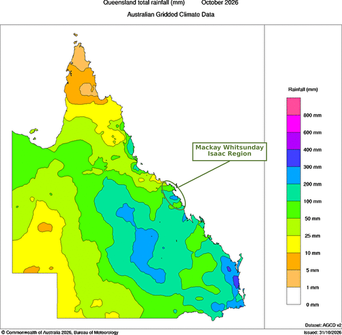
If you’ve had the rain, you’re in a great position. It’s also the best time to get ready for whatever the rest of summer brings. Good growth now is a chance to:
- Build bulk and cover. Letting pastures grow out and set seed builds standing feed and litter. Keeping 70% or more groundcover protects the soil from heat and helps storm rain soak in instead of running off.
- Fill the soil profile. Rain that soaks in and stays in the root zone is moisture in the bank. Monitor your soil moisture rather than just the rain gauge.
- Resist overstocking on green pick. Fresh growth can look like more feed than it is. Matching stock numbers to what the paddock can carry through a dry finish maintains land condition in the long run.
- Set your trigger points. Pick a date or a rainfall minimum that will prompt a decision on stocking rates, feed or planting, so you aren’t deciding under pressure later.
For those in the drier north, you won’t need to be told that those trigger points and monitoring the forecasts matter most right now.
Where to from here?
Check the outlooks regularly, plan for a range of variables, and look after the soil. Soil with living roots and good cover is the best drought insurance we’ve got!
Want to dig deeper?
- BoM long-range rainfall forecasts: click the map to zoom in on our region. Updated every Thursday.
- Australian Water Outlook: root-zone soil moisture: shows how much moisture is sitting in the soil across the region right now.
- Cattle Comfort Index forecast (NACP): a 7-day forecast of heat and cold stress risk for cattle, useful for planning mustering, weaning and trucking.
- LongPaddock: a Department of Primary Industries (DPI) resource to support decisions about forage budgets.
- FutureBeef: access FORAGE webinars and videos to assist in your land management decisions.
- For more climate related resources, you can contact the Bureau’s Agriculture Customer Lead directly at agriculture@bom.gov.au.
With thanks to Emily Hinds, Agriculture Customer Lead with the Bureau of Meteorology’s Agriculture and Water Program, for sharing the climate resources and to Kellie Harmsworth, Sustainable Agriculture Facilitator at Reef Catchments for sharing the grazing management resources.