
Management Interventions to improve Ecosystem Health
Case Study – Alluvium Consulting Report to stabilise stream banks along the O’Connell River.
Stream bank erosion is a major source of sediment in many watercourses. This has multiple implications including degrading water quality, reducing ecosystem habitat and the loss of agricultural land on productive alluvial floodplains.
One of the focuses for improving water quality and ecosystem health in the Mackay Whitsunday region is to stabilise stream banks.
A study has been undertaken to assess stream bank loss and stability of the O’Connell River. A significant proportion of the sediment supply is understood to be from channel erosion with the report seeking to understand the cause of erosion, identify the locations of significant sediment loss, the extent in which it is happening and also the potential for future channel erosion along the river.
To undertake this study a number of tools were utilised including aerial imagery analysis, terrain modelling, hydraulic modelling and field inspections.
Interpretation of the terrain modelling results have highlighted areas of significant channel erosion by comparing digital elevation models (DEM) from LiDar between 2010 and 2014. When the two DEM’s are overlaid a DEM of difference allows quantification of the loss of sediment during the four-year timeframe. Using this comparison the report heighted 31 sites of major bank loss loosing between 1 000m3 to 65 000m3 in the four years between the DEM’s.
The Hydraulic modelling is effective at identifying the management intervention necessary to ensure that the bank does not continue to erode after a management intervention by calculating the stream power along the river. With lower stream power the bank can be stabilised with revegetation alone, however with higher stream power more effort is needed to maintain bank stability.
When the terrain and hydraulic modelling results are interpreted together, major sites of potential erosion have been identified. These sites have high stream power together with large areas of alluviul floodplain with the potential to be eroded.
With major sites identified, Reef Catchments has been engaging landholders to implement bank stabilisation projects which will halt the loss of sediment from the banks and allow the alluvial plains to continue to be utilised for agricultural production.
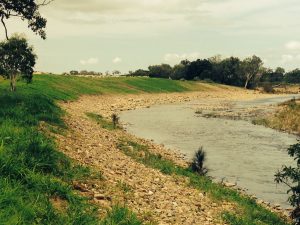
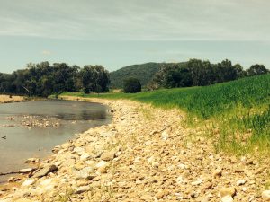
Reef Catchments is working with landholders to implement a range of different measures including rock toes, pile fields and log jams. All initiatives will include bank revegetation, which will maintain bank stability to reduce the sediment loads within the O’Connell and maintain productive alluvial floodplain.
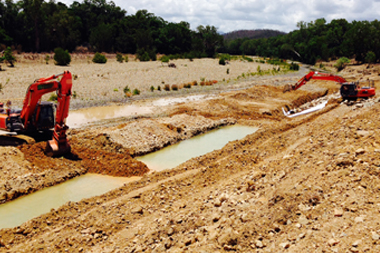
Currently Reef Catchments has undertaken one major project identified from the report to stabilise a bank which has lost 10 000m3 between 2010 and 2014. One dimensional hydraulic modelling identified five potential option ranging from poor to high likelihood of success. Engaging with the landholder and identifying available resources, a two metre rock toe with bank reprofiling was chosen.
Large woody debris will also be embedded to create habitat and the bank will be revegetated to ensure long term bank stabilisation.